Overview
- Location: Lake Tahoe, California (Desolation Wilderness)
- Distance: 10–10.5 miles round trip
- Elevation Gain: ~3,250 feet
- Difficulty: Strenuous
- Trail Type: Out & back (well-marked)
- Season: Late June–October (snow lingers into July; best in late summer/fall)
- Permit: Free wilderness permit required (self-issue at trailhead)

Why Hike Mount Tallac?
- Spectacular panoramic views: Lake Tahoe, Fallen Leaf Lake, Pyramid Peak, Desolation Wilderness.
- Diverse landscapes: Alpine forests, wildflower meadows, granite ridges, lakes.
- True “Sierra Challenge”: A strenuous ascent with a huge payoff.
- Wildlife: Chance to spot marmots, eagles, and even bears.
Getting There
- Trailhead: Mount Tallac Trailhead
- Directions: From South Lake Tahoe, take Hwy 89 north. Turn left onto Mount Tallac Road (signed, across from Camp Richardson), follow to parking lot (~1 mile).
- Parking: Free, fills early on weekends—arrive before 8 am.
- Facilities: Vault toilets at trailhead, but no water.
Trail Description (Step-by-Step)
Mile 0:
- Sign the self-issue wilderness permit at the trailhead kiosk.
- Trail climbs through shady pine forest with glimpses of Fallen Leaf Lake.
Mile 1.5:
- Junction: Floating Island Lake Trail (stay right for Mount Tallac).
- First views of Lake Tahoe, open rocky stretches.
Mile 1.7:
- Floating Island Lake: Shallow, photogenic lake; good first rest stop.
Mile 2.3:
- Cathedral Lake: Another pretty alpine lake, surrounded by granite; last water source (filter recommended if needed).
Mile 2.7:
- Begin the main climb—trail steepens, traverses open rocky slopes with sweeping views.
Mile 4:
- Reach a broad saddle below the summit; enjoy 360° views.
- Final push: Steep, rocky ascent—follow cairns and worn path up the ridge.
Mile 5–5.2:
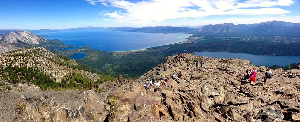
- Summit (9,735 ft): Enjoy incredible views—Lake Tahoe sprawls below, Desolation Wilderness and Sierra peaks in every direction.
- Ample room to rest and picnic.
Descent:
- Retrace your steps—watch footing on steep sections, especially if loose gravel.
What to Bring
- 2–3 liters of water (no reliable water after Cathedral Lake)
- Snacks/lunch, extra food for energy
- Good hiking boots or trail shoes (rocky/uneven terrain)
- Hat, sunglasses, sunscreen (exposed sections)
- Layers (can be windy and cool on the summit, even in summer)
- Hiking poles (recommended for the descent)
- Camera/phone for photos
- Map/GPS (trail is well-marked but can be confusing in snow or fog)
- Wilderness permit (self-issued at trailhead)
- Bug spray (mosquitoes in early summer)
Safety & Tips
- Start early: Beat the crowds, avoid afternoon thunderstorms (common in July/August).
- Acclimatize: Altitude can make the climb tougher—pace yourself and take breaks.
- Leave no trace: Pack out all trash, respect wilderness rules.
- No dogs: Desolation Wilderness allows dogs but leash required; consider rocky, hot terrain and lack of water for pets.
- Snow: In early season, snowfields linger—microspikes or trekking poles may be needed (check trail reports).
Nearby Highlights
- Fallen Leaf Lake: Swim or picnic after your hike.
- Desolation Wilderness: Other trails to Gilmore Lake, Dicks Peak, etc.
- South Lake Tahoe: Lodging, restaurants, post-hike treats.
Quick Reference Table
| Feature | Info |
|---|---|
| Trailhead | Mount Tallac Trailhead |
| Distance (RT) | 10–10.5 miles |
| Elevation Gain | ~3,250 feet |
| Summit Elevation | 9,735 feet |
| Difficulty | Strenuous |
| Permit | Free, self-issue at trailhead |
| Best Season | Late June–October |
| Dogs Allowed | Yes, on leash (bring extra water) |
Pro Tips
- For sunrise or sunset: Start before dawn or plan an evening descent—bring a headlamp!
- Snow travel: Early/late season, check AllTrails or local forums for conditions.
- Celebrate: Lake-view lunch on the summit is a must.